 INSPIRE-1
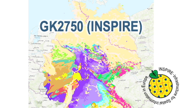
INSPIRE: Geological Map of Germany 1:2,750,000 (GK2750) (WMS)
The WMS GK2750 Geology (INSPIRE) represents the surface geology of Germany on a scale of 1:2,750,000. According to the Data Specification on Geology (D2.8.II.4_v3.0) the geological map provides INSPIRE-compliant data. The WMS GK2750 Geology (INSPIRE) contains layers of the geologic units (GE.GeologicUnit), faults (GE.GeologicFault) and marginal position of the ice shield and the impact crater Nördlinger Ries (GE. GeomorphologicFeature) displayed correspondingly to the INSPIRE portrayal rules. The geologic units are represented graphically by stratigraphy (GE.GeologicUnit.AgeOfRocks) and lithology (GE.GeologicUnit.Lithology). For different geochronologic minimum and maximum ages, e.g. Upper Devonian - Permian, the portrayal is defined by the colour of the geochronologic minimum age (olderNamedAge). In case of the geologic units the user obtains detailed information via the getFeatureInfo request on the lithology, stratigraphy (age) and genesis (event environment and event process).
|
|
Citation proposal
(2020) . INSPIRE: Geological Map of Germany 1:2,750,000 (GK2750) (WMS). http://gdk-inspire-1.ffm.gdi-de.org/geonetwork/srv/api/records/1a509ef3-55e5-426f-8f58-d8f3d2690bc1 |
Simple
Identification info
- Alternate title
- GK2750 (WMS) (INSPIRE)
- Date ( Publication )
- 2020-07-02
- Status
- completed Completed
Point of contact
- GEMET - INSPIRE themes, version 1.0 ( Theme )
-
- Geologie
- Geology
- Keywords ( Theme )
-
- Genese
- genesis
- Petrographie
- petrography
- Stratigraphie
- stratigraphy
- Tektonik
- tectonics
- infoMapAccessService
- inspireidentifiziert
- opendata
- Keywords ( Place )
-
- Germany
- Deutschland
- Spatial scope
-
- National
- Access constraints
- Other restrictions
- Use constraints
- Other restrictions
- Other constraints
- Terms of Use: General terms and conditions, see https://www.bgr.bund.de/AGB_en. For further use provided information has to be cited as follows: GK2750-INSPIRE, (c) BGR Hannover, 2020
- Other constraints
- Dieser Datensatz kann gemäß der "Nutzungsbestimmungen für die Bereitstellung von Geodaten des Bundes" (https://sg.geodatenzentrum.de/web_public/gdz/lizenz/geonutzv.pdf) genutzt werden.
- Service Type
- view
- Service Version
- OGC:WMS 1.3.0
N
S
E
W
))
Coupled Resource
- Operation Name
- getMap
- Coupling Type
- Tight
Contains Operations
- Operation Name
- GetCapabilities
- Distributed Computing Platforms
- Web services
- Connect Point
- https://services.bgr.de/wms/inspire_ge/gk2750/?
Contains Operations
- Operation Name
- GetMap
- Distributed Computing Platforms
- Web services
- Connect Point
- https://services.bgr.de/wms/inspire_ge/gk2750/?
- Distribution format
-
- png (n/a )
- jpeg (n/a )
- gif (n/a )
- OnLine resource
- https://services.bgr.de/wms/inspire_ge/gk2750/?REQUEST=GetCapabilities&SERVICE=wms&VERSION=1.3.0
- OnLine resource
-
Karte im BGR-Geoviewer
Karte im BGR-Geoviewer
- Hierarchy level
- Service
- Other
- Service
Conformance result
- Date ( Publication )
- 2013-04-04
- Explanation
- See the referenced specification
- Pass
- true
Conformance result
- Date ( Publication )
- 2009-10-20
- Explanation
- See the referenced specification
- Statement
- The WMS GK2750 Geology (INSPIRE) based on the spatial dataset of the Geological Map of Germany 1:2,750,000 - Geology (GK2750 Geology) transformed according to INSPIRE.
gmd:MD_Metadata
- File identifier
- 1a509ef3-55e5-426f-8f58-d8f3d2690bc1 XML
- Metadata language
- English
- Character set
- utf8 UTF8
- Hierarchy level
- service Service
- Hierarchy level name
- Geologie
- Hierarchy level name
- INSPIRE
- Date stamp
- 2020-07-14
- Metadata standard name
- ISO19115/ISO19119
- Metadata standard version
- n/a
Point of contact
Overviews
Provided by

Views
1a509ef3-55e5-426f-8f58-d8f3d2690bc1
Access to the portal
Read here the full details and access to the data.
Associated resources
Not available