 INSPIRE-1
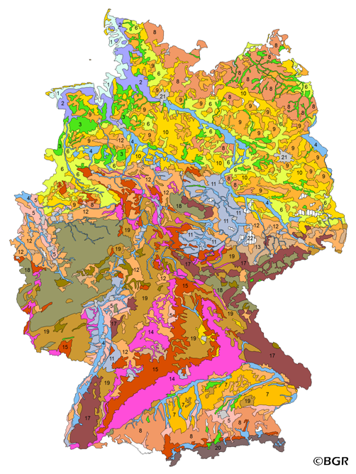
Soil Map of the Federal Republic of Germany 1:5,000,000 (WMS)
Web Map Service (WMS) of the BUK5000. The BUEK5000 is derived form the landuse stratified soil map of Germany at scale 1:1,000,000 by aggregation, focused on information about the parent material, and generalization. The maps shows 20 soil (23) legend units with polygons of at least 64 square kilometers.
|
|
Citation proposal
(2006) . Soil Map of the Federal Republic of Germany 1:5,000,000 (WMS). http://gdk-inspire-1.ffm.gdi-de.org/geonetwork/srv/api/records/31431A40-6BB3-4D79-806A-83BBF869BE69 |
Simple
Identification info
- Alternate title
- BÜK5000 (WMS)
- Date ( Publication )
- 2006-01-01
- Date ( Revision )
- 2003-01-01
- Identifier
- 514cd7da-4fb8-4467-96a0-c805c4d8ba8c
- Status
- completed Completed
Point of contact
- GEMET - INSPIRE themes, version 1.0 ( Theme )
-
- Boden
- soil
- GEMET - Concepts, version 2.4 ( Theme )
-
- Bodenart
- Bodenkarte
- Bodenkunde
- Bodenschutz
- Umweltschutz
- Keywords ( Theme )
-
- Bodenausgangsgesteine
- Bodeneigenschaften
- Bodenform
- Bodengesellschaft
- Bodeninformationssystem
- Bodensubstrat
- Bodensystematik
- Bodenübersichtskarte
- Fachinformationssystem
- Geografisches Informationssystem
- infoMapAccessService
- inspireidentifiziert
- WMS
- opendata
- Keywords ( Place )
-
- Bundesrepublik Deutschland
- Spatial scope
-
- National
- Access constraints
- Other restrictions
- Use constraints
- Other restrictions
- Other constraints
- Allgemeine Geschäftsbedingungen, siehe https://www.bgr.bund.de/AGB - General terms and conditions, see https://www.bgr.bund.de/AGB_en. Die bereitgestellten Informationen sind bei Weiterverwendung wie folgt zu zitieren: Datenquelle: BÜK5000 V3.0, (C) BGR, Hannover, 2005.
- Other constraints
- Dieser Datensatz kann gemäß der "Nutzungsbestimmungen für die Bereitstellung von Geodaten des Bundes" (https://sg.geodatenzentrum.de/web_public/gdz/lizenz/geonutzv.pdf) genutzt werden.
- Other constraints
- Dieser Datensatz kann gemäß der "Nutzungsbestimmungen für die Bereitstellung von Geodaten des Bundes" (https://sg.geodatenzentrum.de/web_public/gdz/lizenz/geonutzv.pdf) genutzt werden.
- Service Type
- view
- Service Version
- OGC:WMS 1.3.0
N
S
E
W
))
Coupled Resource
- Operation Name
- getMap
- Identifier
- 26FA8698-FC0B-4ADA-B8D6-9916B7DA8029
- Coupling Type
- Tight
Contains Operations
- Operation Name
- GetCapabilities
- Distributed Computing Platforms
- Web services
- Connect Point
- https://services.bgr.de/wms/boden/buek5000/?
Contains Operations
- Operation Name
- GetMap
- Distributed Computing Platforms
- Web services
- Connect Point
- https://services.bgr.de/wms/boden/buek5000/?
- Operates On
- Distribution format
-
- png (n/a )
- jpeg (n/a )
- gif (n/a )
- OnLine resource
- https://services.bgr.de/wms/boden/buek5000/?REQUEST=GetCapabilities&SERVICE=wms&VERSION=1.3.0
- OnLine resource
-
Karte im BGR-Geoviewer
Karte im BGR-Geoviewer
- Hierarchy level
- Service
- Other
- Service
Conformance result
- Date ( Publication )
- 2009-10-20
- Explanation
- siehe dazu die angegebene Durchführungsbestimmung
- Statement
- BÜK1000N 2.3, BAG5000 3.0.
gmd:MD_Metadata
- File identifier
- 31431A40-6BB3-4D79-806A-83BBF869BE69 XML
- Metadata language
- German
- Character set
- utf8 UTF8
- Hierarchy level
- service Service
- Hierarchy level name
- Boden
- Date stamp
- 2020-07-22
- Metadata standard name
- INSPIRE Metadata Implementing Rules: Technical Guidelines based on EN ISO 19115 and EN ISO 19119
- Metadata standard version
- n/a
Point of contact
Overviews
Provided by

Views
31431A40-6BB3-4D79-806A-83BBF869BE69
Access to the portal
Read here the full details and access to the data.
Associated resources
Not available