 INSPIRE-1
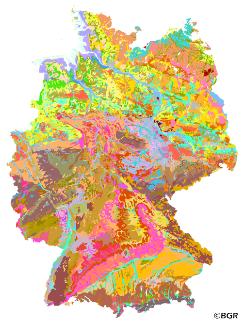
Soil Map of the Federal Republic of Germany 1:1,000,000
Web Map Service (WMS) of the BUEK1000. The first country wide soil map at a scale of 1:1,000,000 (BUEK1000) has been compiled on the basis of published soil maps of the former German Democratic Republic and the pre 1990 federal states of Germany. To do this, it was necessary to match the soil systems used in East and West Germany and to develop standardized descriptions of soil units. A relatively homogeneous map has resulted, which permits uniform assessment of the soils throughout Germany. The map shows 71 soil mapping units, described in the legend on the basis of the German and FAO soil systems. Each soil unit has been assigned a characteristic soil profile (Leitprofil) as an aid to map interpretation. For the first time the subdivision of the country into 12 soil regions has been represented on the map. This subdivision was coordinated with the state Geological Surveys. These soil regions will represent the highest hierarchic level of nation wide soil maps in future. The colours of soil units correspond to the standards of the 'Bodenkundliche Kartieranleitung' (KA 3; Guidelines for Soil Mapping). The various hues characterize differences in relief or soil humidity. The BUEK1000 was produced digitally. It is an important part of the spatial database integrated in the Soil Information System currently being established at the Federal Institute for Geosciences and Natural Resources (FISBo BGR). It can be used together with the characteristic soil profiles to derive thematic maps related to nation wide soil protection. The scale of the BUEK1000 makes it especially suitable for small scale evaluations at federal or EU level.
|
|
Citation proposal
(1995) . Soil Map of the Federal Republic of Germany 1:1,000,000. http://gdk-inspire-1.ffm.gdi-de.org/geonetwork/srv/api/records/D24BFEFA-C159-441D-9877-6623ECBD0978 |
Simple
Identification info
- Alternate title
- BÜK1000 (WMS)
- Date ( Creation )
- 1994-12-01
- Date ( Publication )
- 1995-01-01
- Date ( Revision )
- 2013-12-23
- Identifier
- 4DAD2E3D-82BB-46DA-979D-941B599A3089
- Status
- completed Completed
Point of contact
- GEMET - INSPIRE themes, version 1.0 ( Theme )
-
- Boden
- Soil
- GEMET - Concepts, version 2.4 ( Theme )
-
- Bodenart
- Bodenkarte
- Bodennutzung
- Bodenprofil
- Bodenschutz
- Geographisches Informationssystem
- Umweltschutz
- Freies Schlagwort ( Theme )
-
- infoMapAccessService
- inspireidentifiziert
- opendata
- Keywords ( Place )
-
- Bundesrepublik Deutschland
- Spatial scope
-
- National
- Access constraints
- Other restrictions
- Use constraints
- Other restrictions
- Other constraints
- Allgemeine Geschäftsbedingungen, siehe https://www.bgr.bund.de/AGB - General terms and conditions, see https://www.bgr.bund.de/AGB_en. Die bereitgestellten Informationen sind bei Weiterverwendung wie folgt zu zitieren: Datenquelle: BÜK1000 V2.1, (C) BGR, Hannover, 2013.
- Other constraints
- Dieser Datensatz kann gemäß der "Nutzungsbestimmungen für die Bereitstellung von Geodaten des Bundes" (https://sg.geodatenzentrum.de/web_public/gdz/lizenz/geonutzv.pdf) genutzt werden.
- Other constraints
- Dieser Datensatz kann gemäß der "Nutzungsbestimmungen für die Bereitstellung von Geodaten des Bundes" (https://sg.geodatenzentrum.de/web_public/gdz/lizenz/geonutzv.pdf) genutzt werden.
- Service Type
- view
- Service Version
- OGC:WMS 1.3.0
N
S
E
W
))
Coupled Resource
- Operation Name
- getMap
- Identifier
- d3401588-d0de-41ca-8b25-28768b043067
- Coupling Type
- Tight
Contains Operations
- Operation Name
- GetCapabilities
- Distributed Computing Platforms
- Web services
- Connect Point
- https://services.bgr.de/wms/boden/buek1000de/?
Contains Operations
- Operation Name
- GetMap
- Distributed Computing Platforms
- Web services
- Connect Point
- https://services.bgr.de/wms/boden/buek1000de/?
- Operates On
- Distribution format
-
- png (n/a )
- jpeg (n/a )
- gif (n/a )
- OnLine resource
- https://services.bgr.de/wms/boden/buek1000de/?REQUEST=GetCapabilities&SERVICE=wms&VERSION=1.3.0
- OnLine resource
-
Karte im BGR-Geoviewer
Karte im BGR-Geoviewer
- Hierarchy level
- Service
- Other
- Service
Conformance result
- Date ( Publication )
- 2009-10-20
- Explanation
- siehe dazu die angegebene Durchführungsbestimmung
- Statement
- BGR (BÜK1000, 1.0), Forstplanungsämter und Staatliche Geologische Dienste der Länder von 12/1994 bis 06/1998.
gmd:MD_Metadata
- File identifier
- D24BFEFA-C159-441D-9877-6623ECBD0978 XML
- Metadata language
- German
- Character set
- utf8 UTF8
- Hierarchy level
- service Service
- Hierarchy level name
- Boden
- Date stamp
- 2020-07-22
- Metadata standard name
- INSPIRE Metadata Implementing Rules: Technical Guidelines based on EN ISO 19115 and EN ISO 19119
- Metadata standard version
- n/a
Point of contact
Overviews
Provided by

Views
D24BFEFA-C159-441D-9877-6623ECBD0978
Access to the portal
Read here the full details and access to the data.
Associated resources
Not available