 INSPIRE-1
Topic
geoscientificInformation
707 record(s)
Provided by
Type of resources
Available actions
Topics
Keywords
Contact for the resource
Update frequencies
-
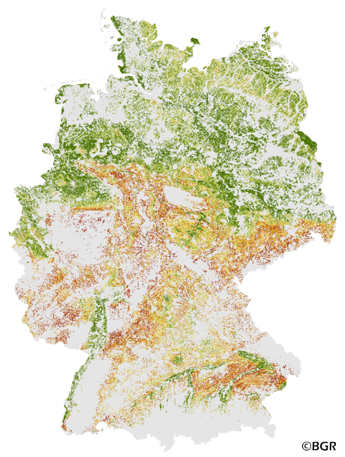
The Potential Soil Erosion Risk map gives an overview of the exposure of arable soils to soil loss due to surface runoff and splash erosion in Germany. It is based on pedological, relief and climatic factors. The map was created by using the long-term model USLE (Universal Soil Loss Equation). The method is published in the DIN 19708:2005-02 and in the documentation of Ad-hoc-AG Boden (representing the soil experts of the geological services of the German federal states). For the application with soil maps, the method was adapted by the Federal Institute for Geosciences and Natural Resources (BGR).The landuse stratified soil map of Germany at scale 1:1,000,000 was used as pedological input to the model. The relief data was derived from the DEM50 of the BKG. The mean annual precipitation data of the period 1961-1990 (DWD) is used to model the erosivity of rainfall. The land use information is derived from CORINE land cover data set (2006).
-
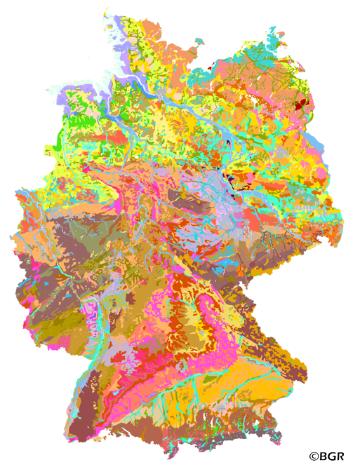
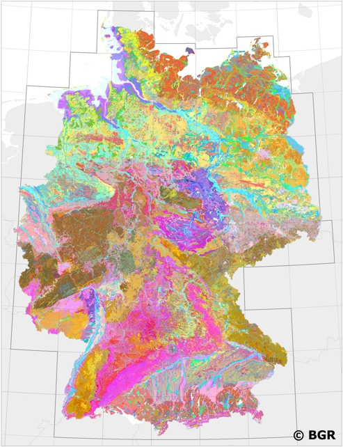
The first country wide soil map at a scale of 1:1,000,000 (BUEK1000) has been compiled on the basis of published soil maps of the former German Democratic Republic and the pre 1990 federal states of Germany. To do this, it was necessary to match the soil systems used in East and West Germany and to develop standardized descriptions of soil units. A relatively homogeneous map has resulted, which permits uniform assessment of the soils throughout Germany. The map shows 71 soil mapping units, described in the legend on the basis of the German and FAO soil systems. Each soil unit has been assigned a characteristic soil profile (Leitprofil) as an aid to map interpretation. For the first time the subdivision of the country into 12 soil regions has been represented on the map. This subdivision was coordinated with the state Geological Surveys. These soil regions will represent the highest hierarchic level of nation wide soil maps in future. The colours of soil units correspond to the standards of the 'Bodenkundliche Kartieranleitung' (KA 3; Guidelines for Soil Mapping). The various hues characterize differences in relief or soil humidity. The BUEK1000 was produced digitally. It is an important part of the spatial database integrated in the Soil Information System currently being established at the Federal Institute for Geosciences and Natural Resources (FISBo BGR). It can be used together with the characteristic soil profiles to derive thematic maps related to nation wide soil protection. The scale of the BUEK1000 makes it especially suitable for small scale evaluations at federal or EU level.
-
INSPIRE theme Geology. Provision of the sediment distribution of the seabed in the North and Baltic Sea.
-
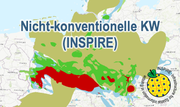
Nicht-konventionelle KW (INSPIRE) presents the results of the NiKo project according to data specifications Energy Resources (D2.8.III.20) und Geology (D2.8.II.4_v3.0). NiKo stands for „unconventional hydrocarbons“, „Nicht-konventionelle Kohlenwasserstoffe“ in German. In the NiKo project the Federal Institute for Geosciences and Natural Resources (BGR) has investigated the potential resources for shale oil and shale gas in Germany. The study was published in 2016 as a report titled „Schieferöl und Schiefergas in Deutschland – Ressourcen und Umweltaspekte“ (available in German only). The colloquial terms shale oil and shale gas refer to oil and natural gas resources in sedimentary shale rock formations, with high organic matter content. In the study, seven formations were identified to have a shale oil and/or gas potential in Germany and their distribution has been mapped in small scale. For each of the formations the organic-rich facies distribution is provided and, if appropriate, the regional potential resource distribution: Fischschiefer (Oligocene), Blättertone (Barremium - Lower-Aptian), Wealden (Berriasium), Posidonienschiefer (Lower-Toarcium), Middel-Rhaetium (Oberkeuper), Permokarbon (Stefanium - Rotliegend) und Lower Carboniferous (Upper Alaunschiefer (Kulm-Facies) + Kohlenkalk-Facies). Corresponding to the overview maps in the report two GML-files for these layers are provided, omitting however the sub-category “possible potential regions”. Bituminous facies distribution (0-5000 m Tiefe) – data specification Geology: GeologicUnit.Distribution_of_bituminous_facies.gml Distribution shale oil and shale gas – potential resources (1000 - 5000 m Tiefe) – data specification Energy Resources: FossilFuelRessource_Potential_resource_regions.gml The distribution maps of the potential resources for shale oil and gas are based on geoscientific criteria. Further non-geoscientific limiting criteria, e.g. exclusion areas, have not been taken into account for the assessment. These assessments are based on appraisements of input parameters naturally with large uncertainties for the potential resources and their distribution in the deep underground. Based on the incipient exploration status of unconventionals in Germany, these resources are considered as undiscovered. The assessed shale oil and gas resources for Germany, represent the order of magnitude of potential resources. Reference: BGR 2016 - Schieferöl und Schieferöl in Deutschland- Potenziale und Umweltaspekte https://www.bgr.bund.de/DE/Themen/Energie/Downloads/Abschlussbericht_13MB_Schieferoelgaspotenzial_Deutschland_2016.html
-
Which salt formations are suitable for storing hydrogen or compressed air? In the InSpEE-DS research project, scientists developed requirements and criteria for the assessment of suitable sites even if their exploration is still at an early stage and there is little knowledge of the salinaries’ structures. Scientists at DEEP.KBB GmbH in Hanover, worked together with their project partners at BGR and the Leibniz University Hanover, Institute for Geotechnics, to develop the planning basis for the site selection and for the construction of storage caverns in flat layered salt and multiple or double saliniferous formations. Such caverns could store renewable energy in the form of hydrogen or compressed air. While the previous project InSpEE was limited to salt formations of great thickness in Northern Germany, salt horizons of different ages have now been examined all over Germany. To estimate the potential, depth contour maps of the top and the base as well as thickness maps of the respective stratigraphic units were developed. Due to the present INSPIRE geological data model, it was necessary, in contrast to the original dataset, to classify the boundary lines of the potential storage areas in the Zechstein base and thickness layers, whereby the classification of these lines was taken from the top Zechstein layer. Consequently, the boundary element Depth criterion 2000 m (Teufe-Kriterium 2000 m) corresponds on each level to the 2000 m depth of Top Zechstein. However, the boundary of national borders and the boundary of the data basis could not be implemented in the data model and are therefore not included in the dataset. Information on compressed air and hydrogen storage potential is given for the identified areas and for the individual federal states. According to the Data Specification on Geology (D2.8.II.4_v3.0) the content of InSpEE-DS (INSPIRE) is stored in 18 INSPIRE-compliant GML files: InSpEE_DS_GeologicUnit_Isopachs_Zechstein.gml contains the Zechstein isopachs. InSpEE_DS_GeologicUnit_Isobaths_Top_Zechstein.gml and InSpEE_DS_GeologicUnit_Isobaths_Basis_Zechstein.gml contain the isobaths of the top and basis of Zechstein. The three files InSpEE_DS_GeologicStructure_ThicknessMap_Zechstein, InSpEE_DS_GeologicStructure_Top_Zechstein and InSpEE_DS_GeologicStructure_Basis_Zechstein represent the faults of the Zechstein body as well as at the top and at the basis of the Zechstein body. InSpEE_DS_GeologicUnit_Boundary_element_Potential_areas_Zechstein.gml contains the boundary elments of the potential areas at the top and the basis of Zechstein as well as of the Zechstein body. The three files InSpEE_DS_GeologicUnit_Uncertainty_areas_ThicknessMap_Zechstein.gml, InSpEE_DS_GeologicUnit_Uncertainty_areas_Top_Zechstein.gml, InSpEE_DS_GeologicUnit_Uncertainty_areas_Basis_Zechstein.gml represent the uncertainty areas of the Zechstein body as well as at the top and at the basis of the Zechstein body. InSpEE_DS_GeologicUnit_Potentially_usable_storage_areas_Storage_potential_in_the_federal_states.gml comprises the areas with storage potential for renewable energy in the form of hydrogen and compressed air. The six files InSpEE_DS_GeologicUnit_Salt_distribution_in_Germany_Malm.gml, InSpEE_DS_GeologicUnit_Salt_distribution_in_Germany_Keuper.gml, InSpEE_DS_GeologicUnit_Salt_distribution_in_Germany_Muschelkalk.gml, InSpEE_DS_GeologicUnit_Salt_distribution_in_Germany_Roet.gml, InSpEE_DS_GeologicUnit_Salt_distribution_in_Germany_Zechstein.gml and InSpEE_DS_GeologicUnit_Salt_distribution_in_Germany_Rotliegend.gml represent the salt distribution of the respective stratigraphic unit. InSpEE_DS_GeologicUnit_General_salt_distribution.gml represents the general salt distribution in Germany. This geographic information is product of a BMWi-funded research project "InSpEE-DS" running from the year 2015 to 2019. The acronym stands for "Information system salt: planning basis, selection criteria and estimation of the potential for the construction of salt caverns for the storage of renewable energies (hydrogen and compressed air) - double saline and flat salt layers".
-
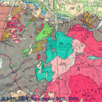
The map series General Geological Map of the Federal Republic of Germany 1:200,000 (GÜK200) is the result of cooperation between the State Geological Surveys of the Federal Republic of Germany (SGD), the Geological Surveys of neighbouring countries and the Federal Institute for Geosciences and Natural Resources (BGR). The GÜK200 displays the surface geology of Germany and adjacent areas of neighbouring countries on 55 map sheets. The map sheets show the regional dissemination of more than 3800 geological units. The geological units contain information on stratigraphy (age), genesis and petrography (composition) of the rocks. Each printed/scanned map sheet contains one or several geological cross-sections which give an insight into the subsurface. The digital data of the map series are stored separately for each map sheet. According to this geological units/polygons, their boundaries, tectonic linear elements and, if present, ice sheet boundaries are saved as a discrete layer in a shapefile for the single map sheets. The attributes of the geological units contain information – like in the printed map sheets – on stratigraphy, genesis and petrography of the rocks.
-
Nation-wide land use strategies and planning as well as soil protection require harmonised and standardised area-covering information. Such data is provided by the digital Soil Map of Germany at scale 1:200,000 (BUEK200). The pedological data of this map, stored in a relational database, is used to demonstrate the abundance and the associations of soils and their basic properties in Germany. However, the main purpose of the BUEK200 is to offer a database which allows the estimation and visualisation of soil functions, soil potentials and soil hazards. To achieve comparable soil information throughout Germany the BGR and the soil surveys of the federal lands have elaborated and defined BUEK200 standards concerning the map (e.g. delineation and description of mapping units) and its database (e.g. database model, parameters, codification).
-
-
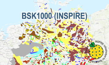
The BSK1000 (INSPIRE) provides the basic information on the spatial distribution of energy resources and mineral raw materials (‘stones and earth’, industrial minerals and ores) in Germany on a scale of 1:1,000,000. The BSK1000 is published by the Federal Institute for Geosciences and Natural Resources in cooperation with the State Geological Surveys of Germany. According to the Data Specification on Mineral Resources (D2.8.III.21) the content of the map is stored in five INSPIRE-compliant GML files: BSK1000_Mine.gml contains important mines as points. BSK1000_EarthResource_point_Energy_resources_and_mineral_raw_materials.gml contains small-scale energy resources and mineral raw materials as points. BSK1000_EarthResource_polygon_Distribution_of_salt.gml contains the distribution of salt as polygons. BSK1000_EarthResource_polygon_Energy_resources.gml contains large-scale energy resources as polygons. BSK1000_EarthResource_polygon_Mineral_raw_materials.gml contains large-scale mineral raw materials as polygons. The GML files together with a Readme.txt file are provided in ZIP format (BSK1000-INSPIRE.zip). The Readme.text file (German/English) contains detailed information on the GML files content. Data transformation was proceeded by using the INSPIRE Solution Pack for FME according to the INSPIRE requirements.
-
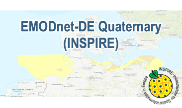
Compilation of the European Quaternary marine geology (section of Germany). The map consists of data at highest available spatial resolution, map scale („multi-resolution“-concept) and data completeness vary depending on the project partner (as of 2019 April). Project partners are the national geological services of the participating countries. According to the Data Specification on Geology (D2.8.II.4_v3.0) the content of the geological map is stored in a INSPIRE-compliant GML file: EMODnet-DE_Quaternary_GeologicUnit.gml contains the geologic units. The GML file together with a Readme.txt file are provided in ZIP format (EMODnet-DE_Quaternary-INSPIRE.zip). The Readme.text file (German/English) contains detailed information on the GML file content. Data transformation was proceeded by using the INSPIRE Solution Pack for FME according to the INSPIRE requirements.